
(Dân Trí) - Meteorological agencies forecast that tonight (September 26), Typhoon Bualoi will enter the South China Sea, becoming the 10th storm of 2025.
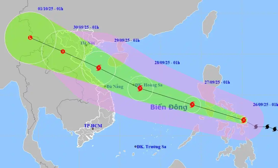
The National Center for Hydro-Meteorological Forecasting reports that at 1:00 AM on September 26, the center of Typhoon Bualoi is located in the central Philippines region. The strongest winds near the storm's center are at level 11 (103-117 km/h), with gusts up to level 14.
The typhoon is moving mainly westward-northwestward at a speed of 25-30 km/h.
It is forecasted that tonight, September 26, the typhoon will enter the South China Sea, becoming the 10th storm of 2025.
Direction of Typhoon Bualoi's movement (Image: NCHMF).
After entering the South China Sea, Typhoon Bualoi is forecasted to continue moving mainly westward-northwestward, potentially intensifying, while maintaining a fast speed of about 25-30 km/h.
By September 28, the typhoon's intensity is expected to reach levels 12-13, with gusts up to level 15.
Due to the influence of Typhoon Bualoi, starting from this afternoon and evening, the waters in the northeastern and central South China Sea will experience winds at levels 6-7, increasing to levels 8-9 afterward. Near the storm's center, winds will be at levels 10-12, with gusts up to level 15, and sea waves reaching 5-7 meters; the sea will be very rough. Vessels in the dangerous area face risks of thunderstorms, tornadoes, strong winds, and large waves.
Meteorological agencies note that the typhoon's path and final destination currently lack high reliability and remain scattered.
Depending on the activity of the subtropical high-pressure system in the coming days, Typhoon Bualoi could head directly toward the Da Nang - Hue area or move along the coast toward the North Central provinces, Northeast region.
Additionally, maritime activities in the northern and central South China Sea areas face risks of very strong winds and large waves from September 27-29.


